
Route Map
Today is the first day of the second half of my trip on the Wales Coast Path. My trusty walking companion, Joanna Elizabeth has returned to base to go back to work while I, happily retired, walk on.
There are twenty one stages to this final section of my Welsh adventure, in addition to the odd day off. Today is a relatively short coastal cliff walk to position myself for a longer and tougher section tomorrow and the day after. The Wales Coast path turns inland from Borth to go up and then down the River Dovey. Over the next week, I will make my way up the coast to Porth Madoc, before heading on to the relatively isolated and sparsely populated Llyn Peninsula. Making my way round and up the peninsula, I will be bypassing Anglesey to head for North Wales and a walk up the Dee Estuary and river to cross back over in to England via the Hawarden Bridge. And there the journey ends. I hope for good weather, particularly on the Lleyn Peninsula, but the long range forecast is not good at all. 'Ca Sera'.
There are twenty one stages to this final section of my Welsh adventure, in addition to the odd day off. Today is a relatively short coastal cliff walk to position myself for a longer and tougher section tomorrow and the day after. The Wales Coast path turns inland from Borth to go up and then down the River Dovey. Over the next week, I will make my way up the coast to Porth Madoc, before heading on to the relatively isolated and sparsely populated Llyn Peninsula. Making my way round and up the peninsula, I will be bypassing Anglesey to head for North Wales and a walk up the Dee Estuary and river to cross back over in to England via the Hawarden Bridge. And there the journey ends. I hope for good weather, particularly on the Lleyn Peninsula, but the long range forecast is not good at all. 'Ca Sera'.
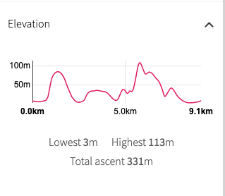
Today's adventure is a nice, short but taxing walk of about six or seven miles. The Ceredigion Coast Path really does have some lovely and occasionally challenging walks. It does not appear to have been as sanitised as some of the other long distance trails and you are, as I heard one walker describe it, 'still walking on the wrong side of the fence'.
There is a steep climb out of Aberystwyth and half way through the walk you have a climb up to Craig y Delyn, an ascent that does its best to be a smaller reflection of Flower Barrow in Dorset. In between there are a number of smaller gullies, as well as some beautiful coastal scenery. The weather is set to be fair and I expect to be walking in sunshine for at least some of the day.
There is a steep climb out of Aberystwyth and half way through the walk you have a climb up to Craig y Delyn, an ascent that does its best to be a smaller reflection of Flower Barrow in Dorset. In between there are a number of smaller gullies, as well as some beautiful coastal scenery. The weather is set to be fair and I expect to be walking in sunshine for at least some of the day.
 Aberystwyth from Constitution Hill
 From my hotel on the North Parade, I headed to the pier area for a walk out of town on or to the side of the B4346 to the area at the bottom of the cliffs to the east of the town. After going through a residential area there is a long and steep climb up a hard path on to Constitution Hill. The hill tops out at about eighty-five metres (nearly two hundred and eighty feet). From the hill top there were lovely views back over the town to the hill of Pen Dinas, location of an Iron Age Fort and the Wellington Monument, which I could see clearly on the hilltop. A memorial to the Duke of Wellington, it is thought to have been built around 1858. Beyond Pen Dinas, I could also see to the mast on Penygraig.
The area around the hill can be busy as there are a number of attractions there, including the cliff railway with seven hundred and seventy-eight feet of track and rising up to four hundred feet. On the top of the hill there is a 'camera obscura', one of the few working cameras in the UK, including one in my home country of Angus, at Kirriemuir. I spent a bit of time talking to people about my walk. It seems carrying a large rucksack is always taken by as an inviation to ask questions.
The area around the hill can be busy as there are a number of attractions there, including the cliff railway with seven hundred and seventy-eight feet of track and rising up to four hundred feet. On the top of the hill there is a 'camera obscura', one of the few working cameras in the UK, including one in my home country of Angus, at Kirriemuir. I spent a bit of time talking to people about my walk. It seems carrying a large rucksack is always taken by as an inviation to ask questions.
 Clarach Bay & headland at Tonfanau
 There was still fairly thick cloud cover around, creating a cold chill to the morning air, which was fine as the climb more than warmed me up and had the muscles in the legs and thighs moving. From Constitution Hill there is a nice but short cliff walk before the descent down to Clarach Bay, The bay itself is lovely but the landward side of the beach is marred somewhat by the extensive holiday village. Coming along the cliffs the view in both directions covered a huge distance between Strumble Head to the rear and the Lleyn Peninsula showing to the fore.
 Clarach Bay & Holiday Villages
 Once clear of the last of the houses of Clarach Bay there is a short rise to regain the cliff and from there onwards it is a cliff walk 'par excellence'. After Clarach you lose the hard path and are walking on a grassy path, for some of the time on a mid-cliff position. This is a lovely walk, with gentle undulations as the path moves toward the descent to the gully at the hamlet of Wallog, with its long shingle spit, Sarn Gynfelyn. The spit is made up of rounded cobbles that have been 'sorted' by nature and grouped by size. Although only a couple of hundred yards of the spit are visible in the photograph, the spit actually extends out in to the sea for about five miles.
The path rises up again on a narrow, stony track, close to the cliff edge and giving a wonderful view of the churning waters and grey shingle beaches below. There is a small element of rise and fall in the path here as it progresses but nothing that particularly taxes the legs or the lungs. Rather, it is one of those sections that encourages you to just stop and look around or, to lend an ear to the soundscape of the place, the sough of the wind, the rustle of the sea or the cry of the seabirds.
On the left, just below Moelcerni, is the location of a blow hole. Shortly after the blow hole the really hard work of the day starts with the ascent to the clifftop at Craig y Delyn. It is a hard and steep climb, even with the assistance of the many steps cut in to the hillside. Despite the steps, I found myself needing to take the odd thirty-second break to catch my breath. About half-way up the hill I stopped and had an interesting conversation with a man who worked for British Rail and who has photographed most of the signal boxes in the UK. He was on a trip to try and capture images of the last few boxes he needed in Wales.


From Craig y Delyn, the highest point of the day, the path is primarily on a downward trajectory, with a couple of undulations to be negotiated before the last challenging descent and climb of the day at roughly Carreg Mulfan. On the descent you are assisted by stairs cut in to the hillside, but it is a rough path on the ascent where you are rewarded at the top with a nice view out over Borth Sands. In the distance, the mountains of Snowdonia march across the skyline, jagged peaks cutting the clouds.
On the beach here there are the remains of a submerged forest that can only be seen when storm conditions have removed the top sand layer. The exposures are indicative of a former fenland / forested landscape. Nearby, archaeological finds on the shore point to human habitation. The age of the remains have been dated using the BP scale (Before Present - taken to mean before 1 January 1950, date when radiocarbon dating began) and suggest a date when the forest was flooded of four to six thousand years ago. Locally, there is a legend that suggests that the site is the location of 'the Sunken Kingdom' of Wales called Cantre'r Gwaelod.
From the low hill above Upper Borth I dropped down into the town to a crossroads, from where I had a road walk out to my campsite at Glanlerry Caravan Park. It was a nice little place, with good facilties and nice level camping pitches. Knowing the weather forecast, I took a pitch underneath the trees, hoping to be protected from the rain that was expected over night. A nice little river flows through the park and later I took a walk along it on a clear path to the back of the town to find a restaurant for a meal.
Although it had been a short day, I think it was one of the best walking days of my trip so far. Not much is heard of the Ceredigion Coast Path, over-shadowed as it is by its near neighbour of Pembrokeshire. But for me, it offered some of the best walking on my Wales adventure so far. To top off the day, I was delighted on my riverbank walk to find a caterpillar of the Yellow-tailed moth inside a Rosa Rugosa. Doesn't get much better!

Caterpillar of the Yellow-tailed moth inside a Rosa Rugosa
 RSS Feed
