After a wee nap yesteray afternoon, I enjoyed a lazy evening around the farm steading and speaking with the farmer. It was the first time I had seen courgette being grown in the ground as a commercial crop and interested to dscuss this with my host. With so many farming tasks now mechanised I presumed bringing in the courgette would be the same. However, it is a labour intensive tasks with up to twenty people following a tractor with a large gantry on the back and the workers cutting the vegetables by hand. Courgette plants are one of those where you can keep coming back for more for pretty much the whole growing season, as long as the main plant is not damaged. They have not invented the machine yet that can do the cutting job as accurately or with as little damage as a human can.
 Cliffe Pools
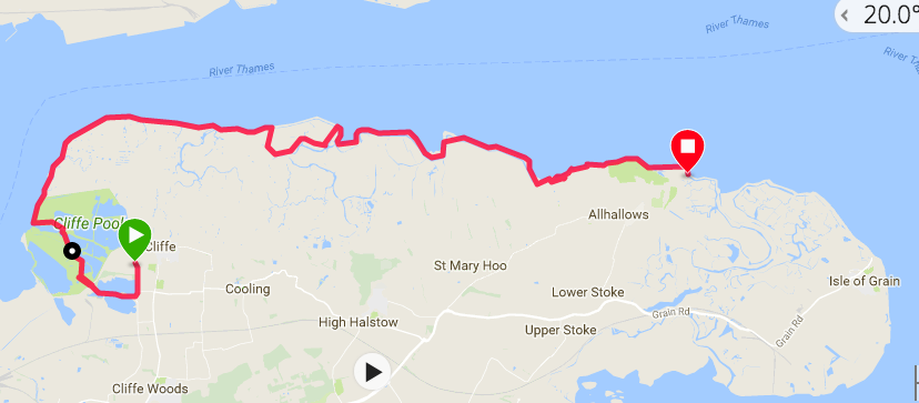
 Tonight was to be a wild camping night so there was no great pressure on me to start walking early. The route today would see me go back pretty much to where I left the Saxon Way yesterday and follow the coastal path round the Hoo Peninsula to somewhere close to the location of the village of Allhallows. When I looked closely at the route I realised that if I were to walk down to the first of the Cliffe Pools to Cliff Fort it would only be to walk back straight back out again to come up Cliff Creek. After arguing with myself about it I decided to miss out going to the fort; it is a ruin now and much of what is left is flooded, instead I would head for the main coastal section of the path and get on with the more straighforward walking of the day. In the photograph, the red dot is my starting point and Cliffe Fort is to the extreme left, middle.
 Warning!
 It was a bright, sunny morning with clear blues skies, albeit there was a little chill to the early morning air. Retracing my steps of yesterday back to the top of the pools, as I stood at the top of the path there was one of the huge conveyor belts disappearing in the distance, heading down to the jetty by the side of the fort. As I progressed down a parallel path I could see the outlines of the fort against the skyline. The fort was built in the mid-nineteenth century as part of the defences for the River Thames during the years of the continental wars. It is closed off to the public now but you can walk round the outside of the walls. The fort was the site for the early guided missile system, the Brennan Torpedo and the remains of the system can still be seen on site. Created by Louis Brennan, the system the first wire-guided torpedo and was in operation on the Thames during the years 1887 - 1903.
 Towards the Thames
 Standing at the bottom of Cliffe Creek there were wonderful views down to the River Thames and over the countryside of Essex on the opposite shore. One the edges of pool the buzz of insect life and the darting flight of butterflies caught the attention. There some lovely bright yellow wild flowers in the damp earth and sharp teazels standing out against the clear blue sky. Back on the seawall again it was all big skies and water with open countryside all around.
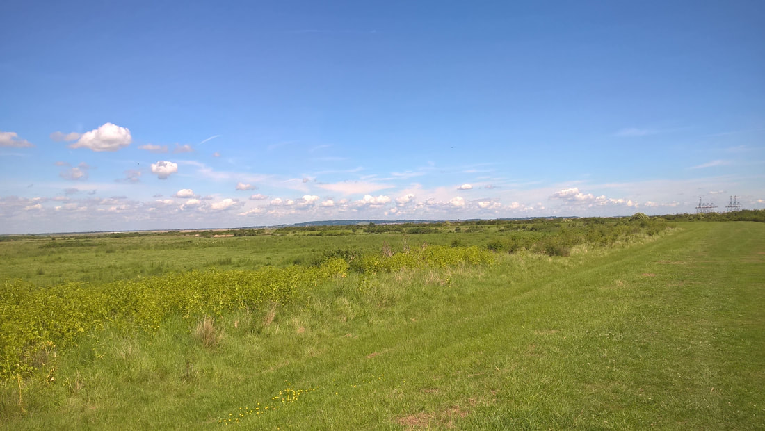
The growth was thick on top of the seawall and the tufty grass and stronger weeds were pulling at my legs as I walked through them. Hidden in the grassess were nettles and thistles and before too long, as I was walking in shorts, my legs were a mass of small blisters from the former and scratches from the latter. Walking on this part of the Hoo Peninsula is a lonely activity as there are not many people who venture beyond the village of Cliff and out to the north east corner of the peninsula. From Cliffe right round to Allhallows there are no houses or farms. It is just wilderness with abandoned industrial buildings and the skeletons of ships. If you walk out here on the seawall the chances are that you will not meet anyone for the fourteen or fifteen miles between the two settlements. The day I walked it there was not even a dog walker to be seen, albeit there was a stranger!
It could have been so different as the area had been identified as a possible location for a London estuary airport. Its future as a wilderness area is still under threat as in April 2017 the Government announced the area to the west as its preferred route for a new Lower Thames Crossing which will cross the Hoo Peninsula at Chalk, just to the south west of Cliff. With major developments creeping ever nearer one wonders how long before the wilderness landscape and all the numerous habitats that it holds are directly threatened.
It could have been so different as the area had been identified as a possible location for a London estuary airport. Its future as a wilderness area is still under threat as in April 2017 the Government announced the area to the west as its preferred route for a new Lower Thames Crossing which will cross the Hoo Peninsula at Chalk, just to the south west of Cliff. With major developments creeping ever nearer one wonders how long before the wilderness landscape and all the numerous habitats that it holds are directly threatened.
Rounding the headland there were good views across to Canvey Island where there was lots of activity around the dock area. With clear blue skies and bright sunshine there was a tremendous feeling of space with everything feeling 'big'. The tide was out and as I walked I could watch the various birds searching in the mudflats. To the landward side, sheep grazed placidly in the shadows of the old ammunitions factory. The colourscape of both land and sea were vibrant, from the bright emerald green of the grass sward on the factory site lying landward, to the glinting diamonds of light bouncing back off the salt water lying atop the mudflat. The soundscape consisted primarily of birdsong, but if I stopped walking I could just pick up the lap of the waves at the water's edge and the gentle sough of the wind across the tops of grass and wildflower. Bees buzzed, butterflies flapped, numerous little blues and brown skippers darting across the tops of the flowers. Walking here on a summer's day it is hard to believe you are within sight of the largest city in the country.


The legal designations that land such as this can possess are numerous from the commonly known SSSI and nature reserve protections to other, slighly more obscure titles related to subjects as diverse as footpath protection, farming, enviromental protection, development plans and reams of European legislation. A slightly unusual one here was attached to the Francis Chalk Quarry which is designated as a RIGS (Regionally Important Geological Site). At the quarry site, near Cliffe, the Upper Chalk level of the Thames Estuary can be seen on the surface.
Another protection relates to the protection accorded mudflats and saltflats, including a feature that means if an area of such habitat is removed for development purposes, a similar sized area must be developed within the local area to replace it. The area where I was walking is part of the Thames Estuary and Marshes Special Protection Area which is a designated RAMSAR site (a wetland site designated of international importance under the Ramsar Convention). As I walked the seawall I came to a section where there was a stunning number of wildflowers covering an area over a mile long, with the flowers covering the top of the seawall, tumbing down the banks and extending a fair distance in both directions, covering the banks of the river and the flat area behind the wall. I had noticed that there appeared to be an extra bay where the seawall had been breached and new mud and saltflats created. It really was the most beautiful sight I had seen on my walk so far. By the time I had walked the length of it my legs from toe to knee, boots and socks were yellow from the pollen of the flowers. It was so unusual as to be a wee bit of a mystery.
Another protection relates to the protection accorded mudflats and saltflats, including a feature that means if an area of such habitat is removed for development purposes, a similar sized area must be developed within the local area to replace it. The area where I was walking is part of the Thames Estuary and Marshes Special Protection Area which is a designated RAMSAR site (a wetland site designated of international importance under the Ramsar Convention). As I walked the seawall I came to a section where there was a stunning number of wildflowers covering an area over a mile long, with the flowers covering the top of the seawall, tumbing down the banks and extending a fair distance in both directions, covering the banks of the river and the flat area behind the wall. I had noticed that there appeared to be an extra bay where the seawall had been breached and new mud and saltflats created. It really was the most beautiful sight I had seen on my walk so far. By the time I had walked the length of it my legs from toe to knee, boots and socks were yellow from the pollen of the flowers. It was so unusual as to be a wee bit of a mystery.
 Mudflats
 About half way along this section of the seawall, I spied a head bobbing up and down on the shore in the middle of the wildflowers. At first I thought it might be a birdwatcher or some other kind of naturalist. However, when I saw he had a clipboard and was writing on it, it was too intriguing not to go down on to the shore and walk out to nearer the waterline where he was ducking and diving. It turned out he was an enviromental surveyor whose job was to ensure that what was claimed to be done was in fact on the ground. The surveyor was surprised to see me, noting that in the year of his fieldtrips to this section he had never met anyone else walking there.
He explained that about a year before, an area around Canvey Island had been extended which had resulted in a section of mudflat being lost. To replace the habitat and provide a new home for the displaced wildlife, a commensurate area of mudflat was created on the opposite bank which entailed breaking the seawall and creating a new tidal zone. When the work was being done they had shipped in hundreds of tons of topsoil to create the new seawall and this had been filled with flower seeds. This was the wonderful vista that was laid out before us. He further noted the likelihood that we would be the only two people ever to see it as it would be short-lived and was unlikely to happen again on the same scale. The salt-laden air and the salt that would build up in the soil through immersion beneath endless tides, would eventually kill off most of the seed. It was a one-off natural occurrence. Over time, other more local, salt-tolerant species would inhabit the site but the profusion would never come close to what we could see. It felt very special then to see and walk through the flowers.
He explained that about a year before, an area around Canvey Island had been extended which had resulted in a section of mudflat being lost. To replace the habitat and provide a new home for the displaced wildlife, a commensurate area of mudflat was created on the opposite bank which entailed breaking the seawall and creating a new tidal zone. When the work was being done they had shipped in hundreds of tons of topsoil to create the new seawall and this had been filled with flower seeds. This was the wonderful vista that was laid out before us. He further noted the likelihood that we would be the only two people ever to see it as it would be short-lived and was unlikely to happen again on the same scale. The salt-laden air and the salt that would build up in the soil through immersion beneath endless tides, would eventually kill off most of the seed. It was a one-off natural occurrence. Over time, other more local, salt-tolerant species would inhabit the site but the profusion would never come close to what we could see. It felt very special then to see and walk through the flowers.


 Over borrowdyke, reed beds & marsh
 With great reluctance I moved on, leaving the wildflowers behind but not without quite a few backward glances and shakes of the head. The River Thames continued to weave its way past Canvey Island, while to my right a series of marshes dominated the inward landscape. First there was Cliff Marshe, which was once a tidal sea right up to the edge of the village of Cliffe until drainage and seawall construction caused the sea to retreat. Cooling Marsh, which runs inland to the village of Cooling, which also figured in Dicken's 'Great Expectations', with the burial places of Pip and others said to be located here. Finally, Halstow and St Mary Marshes, with the latter running up to just before the village of Allhallows.
The marshes are all part of a Marine Protected Area, defined as 'a clearly defined geographical space, recognised, dedicated and managed, through legal or other effective means, to achieve the long-term conservation of nature with associated ecosystem services and cultural values'.
There are an amazing number of bird species in the marshes from the small ones llike wheatears to the the larger birds of prey. Looking over the area, it is initially dominated by the 'boroughdyke', the stretch of water created when the land behind the seawall was excavated to create it. Inland of that it is a patchwork of the clumpy areas of marsh, ditches and standing pools. It is surprisingly vibrant green in the early summer sunshine.
The walking was striaghtforward now on a good path on top of the seawall. Between long straight stretches I walked in, along and back out of the main Egypt and St Mary's Bays. In the distance I could see the buildings of Allhallows and knew it was time to start looking for a campsite for the night. It was still reasonably early, about 5.00pm, so I would need to sit for a while before pitching up.
I needn't have worried because the distance was slightly deceiving and it took me well over an hour to walk to the edges of the village. My plan was to camp on the flat plain to the landward side of the seawall. You would think it would be fairly straightforward. As you look at the ground, particularly in photographs, it always looks putting green flat. But when you get closer there are usually huge ruts where tractors and other wide-rimmed vehicles have driven. In the event, I was out the other side of the town before I found a section where I might be reasonably comfortable and I though, undisturbed. It was still a bit close to habitation and I had a wait of over an hour before the trail of dog owners had stopped bringing pooch for his daily walk. Dog dirt is often another obstacle to camping!
Just as the gloaming set in I pitched up, made dinner and had a last half hour on the seawall just watching the river. Just after I had settled down for the night there was another late-night visit from a dog walker whose hound was not happy at my tent being where it was. The dog owner shouted asking if there was anyone in the tent but I resisted the temptation to answer and she went away. Secure in the knowledge that I would be away before anyone returned the next morning, I drifted off to dreamland.
 RSS Feed
